No audio available for this content.
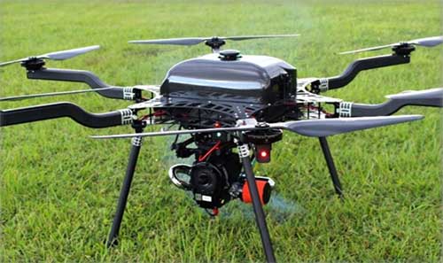
Lidar USA is integrating its UAV scanning systems with the Harris Aerial H4/H6 Hybrid multicopters.
As surveyors and mappers experience growth, they assume larger and larger projects, making longer flight times increasingly important. The Harris Hybrid can provide such flights with lidar and industrial-grade cameras, allowing for far greater coverage in a single flight.
“The beauty of the Harris Hybrid, is that the pilot continues to enjoy the flexibility of a multicopter, availability of fuel, and relatively compact packaging at an affordable price,” said Jeff Fagerman, CEO of Lidar USA. “While it is louder than an all-electric system, for particularly large, rural projects it is a very nice solution.”
Harris Aerial, a drone manufacturer near Orlando, Florida, builds and sells heavy-lift hybrid multicopters. These copters use a small generator running on 95 (or higher) octane fuel to power the UAV for up to 5 hours. The H6 can carry an A-series HD lidar system of 3 kg for 2.5 hours and a V-series of 5 kg up to 1.5 hours.
For the lidar operator, most projects require only one or two flights. On projects that are relatively flat with a clear line of sight to the horizon in all directions, these systems can cover everything legally possible in a single flight.
Lidar USA offers the Harris Aerial H4/H6 Hybrid an integrated package with any Lidar USA scanning system.