No audio available for this content.
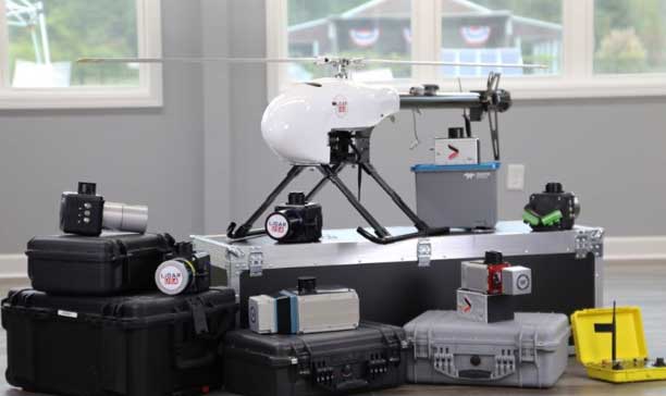
The UAV market has been growing rapidly for the past several years, especially in the U.S. with the Federal Aviation Administration (FAA) Part 107 regulations becoming active in August 2016. Before then, it was impossible to tell what systems were real and would weather the marketplace, and which were just a dream. Multicopters dominate the marketplace. (DJI’s M600 — out since 2016 — offers a 1–6-kilogram payload option). In late 2019, InnoFlight introduced the Galaxy 950 unmanned helicopter, a single-rotor platform capable of carrying more than 6 kilograms. It is available with battery power only, providing flights under an hour, but soon will support a gas-driven option for flights exceeding 2 hours. The system can be ready to deploy in less than 10 minutes.
Lidar USA provides a range of available lidar systems weighing about 5 kilograms, which work well with heavy-lift systems such as the Galaxy 950. In 2019, the Optech CL-90 was released; later the same year, the CL-360 hit the market. Lidar USA integrated each scanner into its product family and immediately saw the possibilities with the Galaxy 950.
The Lidar USA CL-series, together with the Galaxy 950, easily falls in the under-55-pound category set by the FAA. This means users can tackle small (5-acre) and large (500- to 5,000-acre) mapping jobs with confidence in their drone platform, the quality of the scan data, and the resulting lidar point cloud. The Galaxy 950 can easily support the CL-series with supporting cameras. The Optech CL-series provides survey-grade lidar accurate data: +/– 0.01 foot from a car on a paved surface. The system can operate from 400 feet with scan lines every inch at speeds of 14 mph (6.3 m/s). Of course, not all pulses make it to the ground due to vegetation, but the Optech CL-series provides up to four echos per pulse with a small beam size of 0.3 milliradians. Depending on the clipping angle, the scan width can range upwards of 1,200 feet, equating to about 34 acres per minute along a corridor. This system provides the surveyor with high-quality, accurate and dense lidar data.