No audio available for this content.
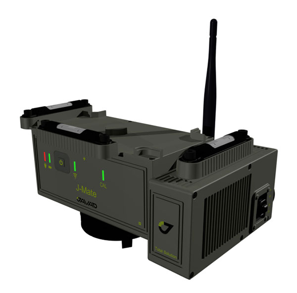
Javad GNSS has taken the power of its Triumph system and expanded to ground-based measurement technologies (versus satellite-based positioning) with the J-Mate.
The J-Mate is a new measurement module that combines conventional measurement via laser scanning and photographic imagery with the multi-constellation location accuracy of the Triumph-LS receiver.
Unlike most conventional total stations, J-Mate does not contain optics for manual use. It does, however, utilize precision horizontal and vertical encoders for angular measurement while the high-definition camera and laser module combine to locate the USB-powered target for accurate measurements, the company said.
The target rest on top of the receiver and lights up for better visibility to the camera and sensor. The lighting power comes through the USB cord connected to the receiver.
Coupled with the onboard data collector screen of the Triumph-LS, operation of the module is done visually with the LS mounted on top of the module or remotely on the J-Pod pole used for GNSS data collection.
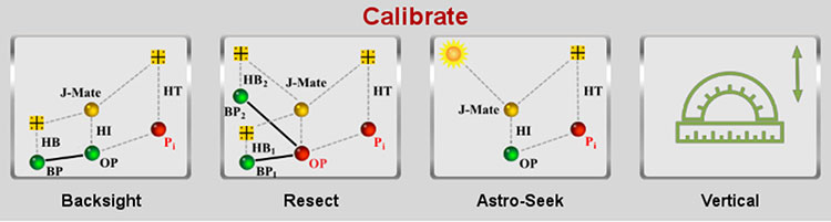
Setup of the module for survey data collection can be accomplished by several different methods: Backsight, Resect or Astro-Seek.
The Backsight method of station establishment, while following in the manner of traditional total stations, can be accomplished by several different methods utilizing the J-Mate and Triumph-LS.
- The first option is to occupy a known station with pre-established horizontal and vertical values, and then proceed to orient the instrument to another known station.
- The second option is using the Triumph-LS GNSS engines to establish a station coordinate value, perform the same procedure on the reference station, and use the J-Mate software to calculate backsight azimuth for orientation.
- The last option is to use a combination of the known coordinates or collect GNSS-derived values for either station or backsight point and complete the station setup.
The Resect method is utilized when occupied station cannot use GNSS-observed coordinate values but can view two or more stations with known values. Once the user has measured all the visible know stations, the data-collection software provides geometric precision analysis and a coordinate solution if tolerances are acceptable.
The last method of orientation, Astro-Seek, can observe solar or lunar positions to accurately determine the location and orientation of the station. The user installs a darkening filter for solar observations and starts the Astro-Seek process; the module automatically makes necessary remaining measurements and calculations.
The J-Mate system is equipped with system parameters that allows the user to customize a variety of settings, including minimum and maximum collection distance, windowing of project area, and edge definition tolerance to fine tune scanning small objects. Also definable within the window area is the scan spacing variable, used to minimize the number of data points where needed.
According to Javad GNSS, the range of the J-Mate is rated at 100 meters (328 U.S. survey feet) using the Javad target and to most white surfaces, while the rating for darker surfaces is 50 meters (164 U.S. survey feet). Three precision vials are placed around the top for visual verification of levelness in addition to the electronic leveling mechanism, giving the user on-the-fly notification of any unstableness of the instrument.
The J-Mate isn’t exclusively a data collection system, though; this module and software is also designed to be an efficient staking application. Taking advantage of robust servos and effective targeting system, this system performs dutifully for staking applications where accuracy and precision are required.