No audio available for this content.
By Ethan Sorrelgreen
Chief Product Officer, Carmera

Since the early days of autonomous vehicles (AVs), maps — specifically, so-called “high-definition” maps — have played a critical role in their technology stack. Central to perception, localization and path planning, these highly detailed, highly precise maps provide vehicles a baseline understanding of the world around them, delivering key priors that form the basis of the AV’s navigational decision making.
These maps come with exacting standards: a 3D network graph, spatial accuracy within 10 centimeters, attribute support in the thousands, and so on. Additionally, with AV deployments becoming more frequent — covering broader, more complex driving domains — these requirements are growing ever more demanding.
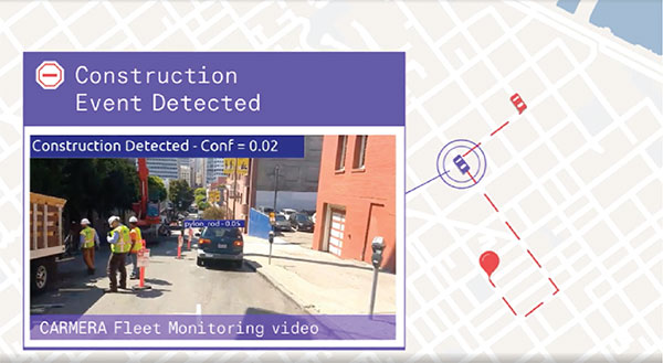
Of particular import is the increased need for temporal accuracy — that is, a map’s ability to represent current conditions (as opposed to conditions at some point in time). Roads — especially urban roads — are highly dynamic environments. Things like construction, repaving, signal upgrades and, now, on-street dining constantly affect the flow of traffic.
For example, in a summer 2020 survey of New York, Carmera found 88 drive-lane-impacting events (out of a total of 251 road events) over 72 hours in midtown Manhattan alone.
A map’s failure to reflect such events and changes can have a major impact on an AV’s reliability (Will the autonomous-driving feature remain engaged?), motion-planning (Will the AV safely and smoothly navigate through/around the obstacle?) and/or path planning (Will the AV choose the most efficient route despite the obstacle?). Maintaining a map, however, is exponentially more complicated than creating it. Not only does the data need to be good, it also needs to be fast and cheap to produce.
The key to solving the fast and cheap legs of this classic “good-fast-cheap” trilemma is simplifying the initial problem, using what Carmera calls a medium-definition map. If an HD map is a map with high feature detail and high spatial accuracy, then an MD map is a map with high feature detail but a slightly lower spatial accuracy. It essentially atomizes the dense, complex HD world into discrete, manageable blocks, or “zones.”
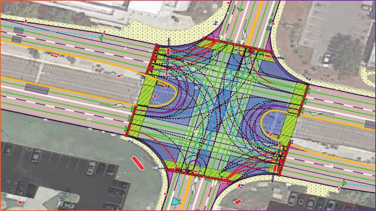
These zones — each a logical section of the road network — become the new unit of fidelity. The MD map catalogs all the features in a zone — a traffic light with a left arrow that controls the left two lanes, a bike path, a solid median, etc. — but not their precise location in the real world.
This simplified map provides the ideal basis for a system of triaging change, which dramatically lowers the cost — in both time and money — of HD map updates. Indeed, it provides the foundation for Carmera’s change-as-a-service offering — a modular, on-demand feed of road events and map updates that plug into existing consumer or HD maps.
Because of its lower spatial accuracy, an MD map can be updated with consumer-grade tools — a camera and a consumer-grade GNSS, let’s say — coupled with basic consumer vision algorithms. Contrast that to an HD map, which requires either expensive equipment, like a lidar rig, or — in Carmera’s case — sophisticated algorithms that can convert visual and telemetric data into HD road graphs.
MD map maintenance, therefore, is relatively cheap, which is good news for those who want to use MD data for next-generation consumer applications, such as natural-language navigation, or to support sub-L4 levels of automated driving (both excellent MD use cases).

For HD updates, an additional pass is needed. Think of this as a tip-and-cue system: When a functional change in the map is detected (the tip), data from the identified zone is reprocessed using more complex algorithms to create the new HD vectors (the cue). In some cases — either because of customer requirements or because the change is superficial — a simple MD update may be sufficient. Thus, expensive computing resources are only deployed when needed.
This approach is equally effective for those using traditional lidar-based methods. There, the MD tip allows for targeted dispatching of lidar rigs, which results in significant cost-savings vis-à-vis the typical practice of sequential resurveying.
As technology evolves, so too will the role of the MD map.
Carmera sees a world where an AV’s onboard sensors will become so sophisticated that the HD maps’ utility may diminish. MD maps, however, will still provide vehicles key rules-of-the road relationships, helping optimize route planning and similar beyond-line-of-sight decision making. Employing this new standard now, therefore, not only makes driving safer today, it paves the way for the road ahead.