ComNav Technology: Proving high-tech is not a last resort

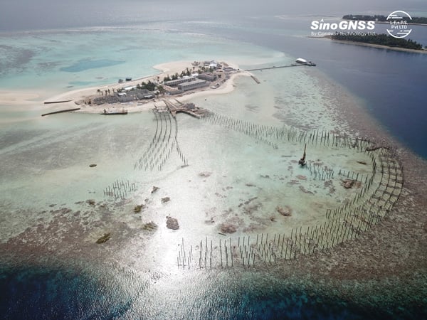
ComNav’s high-accuracy PileMaster sped construction of the Aarah Resort in the Maldives. Photo: LANKA Foundation and Piling Services Pvt. Ltd.
The construction of the Aarah Resort in the Maldives involved building 64 luxury water villas and 12 beach buildings on a shallow-water area with about 1,400 piles. LANKA Foundation and Piling Services Pvt. Ltd. was able to complete the piling project in only 32 days by using a high-accuracy piling solution from ComNav Technology Ltd.
The traditional piling approach requires many surveyors to stake out the positions of the piles underwater in advance. Not only is this process labor-intensive, it also creates a real-time problem: even if the coordinates are measured accurately by lofting, the primary coordinate markers are soon out of position due to the movement of the piling machines. The stakeout’s accuracy is also threatened by strong waves, ocean currents and coral reefs. Furthermore, in the subsequent piling process, the piling accuracy is reduced due to artificial aiming. During the whole process, surveyors must work in the water and fix the piles at short range, which is dangerous. For these reasons, the traditional piling approach is a low-efficiency, high-cost and high-risk operation.
ComNav’s professional positioning solution for high-accuracy piling provides a 9-inch high-resolution tablet with an integrated GNSS receiver, a T300 GNSS receiver as the base station, and two AT340 antennas with magnetic mounts combined with PileMaster software. Its integrated GNSS receiver tracks GPS, GLONASS and BeiDou signals, enabling the system to work even in challenging environments. The system can acquire real-time kinematic (RTK) corrections via an internal UHF transceiver from the T300 receiver or connect to a local continuously operating reference station (CORS). Moreover, PileMaster is designed with an intuitive interface with clear element-management capability, supporting import of up to 10,000 points from Excel, TXT and CAD formats to meet the specific demands of a high-accuracy piling project.
Compared to the traditional piling method, ComNav’s intelligent control system for piling is an all-weather, high-accuracy solution with the additional advantages of being widely compatible and easy to manage. Through software system control and real-time processing and display, it can greatly reduce the number of surveyors required on-site. The system can guide users to the location, shorten the construction period, save construction costs, and enable intelligent visualization and monitoring to ensure high-precision construction work.
After a first successful application in 2017, Foresight Surveyors Pvt. Ltd, ComNav’s local partner in the Maldives, used the solution in many projects, including construction of the Kunaavashi Resort & Spa in 2018 and the Kuda Villingili, Dhigufaru Island and Maniya Faru resorts in 2019.


Follow Us