No audio available for this content.
Australian company Cohda Wireless has released a vehicle positioning system to eliminate GPS black spots in “urban canyons” between high-rise buildings.
Using Cohda’s expertise in developing collision avoidance systems for mines, the vehicle-based system, V2X-Locate, can identify vehicle position to sub-meter accuracy in environments that degrade GPS accuracy, such as tunnels, underground carparks and between high-rise buildings.
As well as enhancing current connected vehicles, V2X-Locate delivers a critical component for connected autonomous vehicles (CAV), which will require uninterrupted positioning data to safely navigate on roads, the company said.
Cohda has designed V2X-Locate to enable equipped vehicles to identify their location using existing Smart City V2X (vehicle-to-everything) roadside infrastructure from any standards-based manufacturer.
Cohda Wireless Chief Technology Officer Paul Alexander said V2X-Locate was a globally unique product. “We solve the problem caused by GPS and satellite-based positioning systems not working in all use-cases,” he said.
“If you’re in a major downtown area with tall buildings, or in a tunnel or in an underground parking lot, a GPS system can fail, preventing it from delivering accurate results,” Alexander said. “As well as being inconvenient for current drivers, this is not an option as we enter the era of driverless cars. The V2X-Locate breakthrough is to position the vehicle with sub-meter accuracy by using the existing communications signals produced by V2X Smart City infrastructure deployments. The result is that V2X-Locate can eliminate positioning black spots in city centers where they are most likely to occur.”
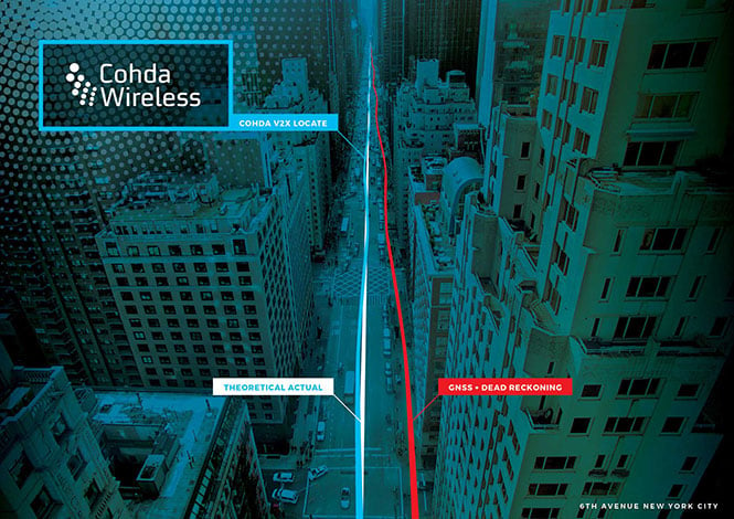
Cohda Wireless demonstrated V2X-Locate in a 2017 trial in New York City, where it repeatedly demonstrated sub-meter accuracy while driving along Sixth Avenue, which has the tallest buildings in the Big Apple. Comparably tested GPS-based systems were as much as tens of meters off-course, at times showing cars driving through buildings.
Alexander said Cohda Wireless had designed V2X-Locate by using its experience developing collision avoidance technology for underground mines. “The hardest place to do positioning is one kilometer underground with a cubic kilometer of copper above your head,” he said.
“That’s where V2X-Locate was born,” Alexander said. “Cohda has worked in that area for several years, providing accurate positioning for vehicles where no GPS connectivity is available. We’ve now successfully migrated that technology from mine sites of the outback to the urban canyons of New York City.”

Both Cohda’s standard V2X onboard units and roadside units use the NXP RoadLINK chipset, which supports V2X-Locate’s highly accurate performance by delivering multipath channel tracking.
After a pre-release international roadshow in October last year, Cohda Wireless received strong interest in V2X-Locate from both Smart Cities and Tier 1 automotive manufacturers. To meet that demand, Cohda Wireless has released a V2X-Locate Evaluation Kit, which contains the system and four roadside unit devices, which equip prospective customers to put V2X-Locate through its paces.


