February 17, 2026 New Emesent GX1 is all-in-one SLAM lidar, RTK and 360° imagery scanner By Tracy Cozzens
February 16, 2026 Pakistan demonstrates advanced Pak-SBAS navigation system in desert rally By Tracy Cozzens
February 10, 2026 Divirod, OKI completes advanced GNSS-R terrain monitoring project in Fukuoka Prefecture By Tracy Cozzens
February 9, 2026 Aptella offers free RTK positioning for bushfire and flood recovery volunteers By Tracy Cozzens
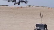
February 2, 2026 Cleared for the dirt: How robotic rovers are revolutionizing military runway assessment By Pieterjan De Meulemeester, Alain Muls, Jarno Van Audenhoven, and Pascal De Kimpe
January 28, 2026 European PAVE-SCAN project aims to increase transport efficiency, safety By Tracy Cozzens