No audio available for this content.
Early Open Services delivered by the Southern Positioning Augmentation Network (SouthPAN) are now live in Australia and New Zealand, improving location-based capabilities for the Australasia region.
SouthPAN provides accurate, reliable and instant positioning services across all of Australia and New Zealand’s land and maritime zones without the need for mobile phone or internet coverage. It will improve positioning from 5-10 meters, to as little as 10 centimeters — a 50-fold increase in accuracy.
The SouthPAN satellite-based augmentation system (SBAS) test-bed project took place between 2017 and 2019, demonstrating the value of SouthPAN to Australian and New Zealand economies and communities. Economic analysis indicates that it is more than $6.2 billion for Australia alone.
In February 2020, Geoscience Australia and Toitū Te Whenua Land Information New Zealand (LINZ) began a joint collaboration on SouthPAN under the Australia New Zealand Science, Research and Innovation Cooperation Agreement (ANZSRICA). A comprehensive procurement process followed, awarding an AUD$1.18 billion, 19-year contract on Sept. 16 to Lockheed Martin Australia.
“The SouthPAN project team will work with Lockheed Martin Australia to establish a network of Global Navigation Satellite System reference stations, a corrections processing facility and satellite uplink facilities that will enable accurate and reliable positioning signals to be transmitted from satellites to users,” said Madeleine King, Minister for Resources and Northern Australia. “The SouthPAN services will be fully operational across the two countries with safety-of-life certification from 2028.”
Benefits from SouthPAN
With early Open Services, Geoscience Australia and Toitū Te Whenua Land Information New Zealand enable industry access to SouthPAN. Early Open Services can immediately integrate with existing equipment or products, to create or enhance positioning service offerings to end-users.
Early Open Services will bring widespread benefits across agriculture, construction, resources and many other industries, paving the way for technological advancements in automation, including:
- heavy vehicle automation, such as truck platooning, where vehicles can connect to each other as a group to transport goods
- precision agriculture applications such as yield mapping, controlled traffic farming, inter-row seeding, precision spraying and livestock management
- personnel safety on mine and construction sites, through smart geofencing technologies that accurately identify the locations of workers with key equipment, such as vehicles and heavy machinery.
SouthPAN is estimated to generate more than AUD$6 billion in benefits to the Australian economy over the next 30 years.
King said the new network will allow
- mining companies to install more accurate collision avoidance systems on automated mining haul trucks
- visually impaired citizens to navigate cities with pinpoint assistive technologies
- light aircraft to land more safely in remote rural areas in all weather conditions, including essential services such as The Royal Flying Doctor Service.
The joint Australia-New Zealand initiative will be a game-changer for the economies of both nations, said Damien O’Connor, New Zealand minister for land information.
“This technology was originally developed to support aviation safety, but as technology has advanced, the applications have expanded,” O’Connor said. “It now has potential uses as varied as enabling accurate vehicle guidance for efficiencies in agriculture and horticulture management, tracking maritime shipments, and enabling navigation for drones and other unmanned vehicles.”
Early Open Services
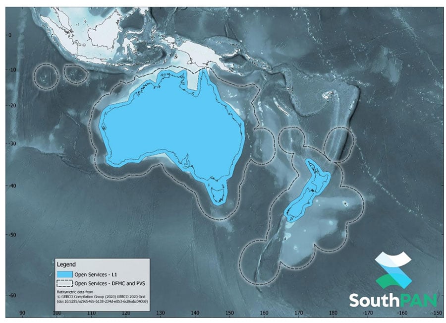
SouthPAN will provide three early Open Services.
L1 SBAS Open Service. The L1 SBAS early Open Service will provide navigation messages on the L1 frequency (1,575.42 MHz), and allow users with a receiver that tracks GPS L1 C/A signals to improve their position accuracy to better than ≤3m in the horizontal and ≤4 m in the vertical (95% confidence interval).
DFMC SBAS Open Service. The Dual-Frequency Multi-Constellation SBAS early Open Service will provide navigation messages on the L5 frequency (1,176.45 MHz), and allow users — with a receiver that tracks GPS L1 C/A and L5 signals, and Galileo E1 and E5a signals — to improve their position accuracy to better than ≤1.5m in the horizontal and ≤2.5 m in the vertical (95% confidence interval).
PVS Open Service. The Precise Point Positioning (PPP) via SouthPAN (PVS) early Open Service will share the L5 frequency with the DFMC SBAS Open Service in the near future, before transitioning to a new navigation signal. PVS will allow users — with a receiver that tracks GPS L1 C/A and L5 signals and Galileo E1 and E5a signals, and is capable of processing the PVS messages — to improve their position accuracy better than ≤0.40 m in the horizontal and ≤0.55 m in the vertical (95% confidence interval) after convergence. Convergence will be better than 80 minutes during PVS early Open Services, and the user does not need to remain stationary during the convergence period.
More information is available in the SouthPAN Open Services factsheet for end-users and in the SouthPAN Service Definition Document (SDD) and Disclaimer.
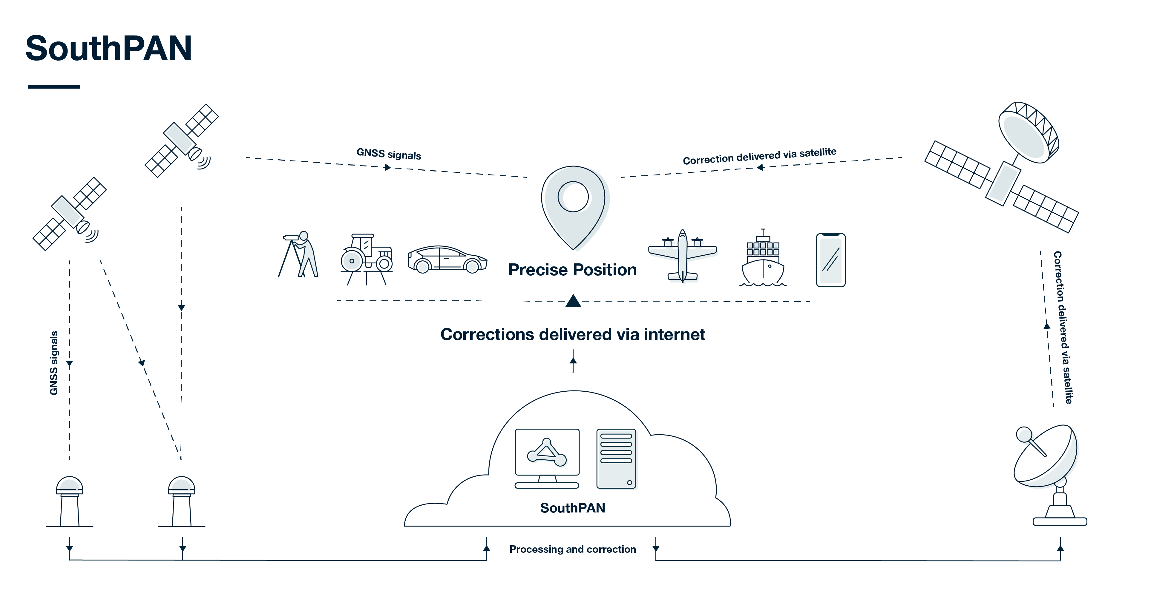
How SouthPAN works
SouthPAN uses several distributed ground stations to monitor signals broadcast by GNSS satellites, and compares each station’s known location with position data from the satellites.
The GNSS signal data and measurement information is sent to correction processing facilities. The facilities aggregate the data from all ground stations, produce error corrections and status information about the GNSS satellites, and format the data in a standardized series of messages. These messages are sent to an uplink station, which transmits the data to a satellite in geostationary earth orbit. The data is broadcast to all precise positioning users, who combine SouthPAN’s data with their own observations of GNSS satellites.