TAG: Germany

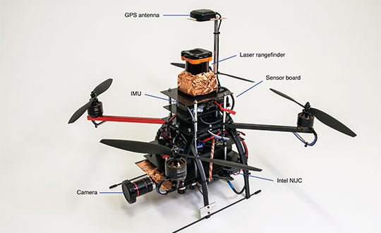
FIGURE 1. Components of the quadrotor helicopter. (Photo: K. Mueller, J. Atman, N. Kronenwett & G.F. Trommer)

Innovation: A multi-sensor navigation system for outdoors and indoors

November 20, 2020

An aerial view of Laacher See, a volcanic caldera lake with a diameter of 2 km in Rhineland-Palatinate, Germany. Created by volcanic activity, maars like this are also found in other parts of Europe and on other continents, but Eifel-Maars are the classic example worldwide. (Photo: bbsferrari/iStock / Getty Images Plus/Getty Images)

Research Roundup: GPS reveals volcanic activity under Europe

July 27, 2020

Photo: iStock/Getty Images Plus/Getty Images

Seen & Heard: Speed traps and rescuing koalas

July 1, 2020

Logo: Munich Satellite Navigation Summit

Munich Satellite Navigation Summit canceled due to coronavirus

March 10, 2020

When completed, the underwater auto and rail tunnel will connect Germany and Denmark. (Image: Femern A/S)

GNSS to assist construction on tunnel from Germany and Denmark

March 4, 2020

The MESAS measuring vehicle is 14.5 meters long and weighs 22 tons. At speeds of up to 80 km/h, MESAS records road condition parameters with high precision. (Photo: BASt)

Highway scanning/GNSS system moves forward in Germany

December 11, 2019

This article is tagged with , , , and posted in Latest News, Transportation
Image: GPS World

NovAtel debuts PwrPak7-E2 at Intergeo 2019

September 29, 2019

This article is tagged with , , , , , and posted in Videos
According to Mitsubishi Electric, its Mobile Mapping System uses car-mounted GNSS antennas, laser scanners and cameras to gather 3D positioning data for road assets with high-level accuracy. (Photo: Mitsubishi Electric)

Mitsubishi Electric launches High Precision Positioning Systems Division

August 31, 2019

This article is tagged with , , , and posted in Latest News