
After the mission, a Post-Processed Kinematic (PPK) software gives access to corrections and brings your project to the centimeter accuracy, enhances the overall project, and repairs some data loss during the survey or installation error. In other words, it can save the day!
Mainly used with high-end IMU/GNSS systems, post-processing is now accessible to all surveying applications, even with the powerful Virtual Base Station (VBS) mode.
How does Post-Processing Work?

An Inertial Navigation System, also called INS, embeds an IMU (Inertial Measurement Unit) that contains gyroscopes, accelerometers, and sometimes magnetometers on the one hand, and the GNSS (Global Navigation Satellite System) receiver on the other hand. In real time, navigation systems use “causal” filters such as Extended Kalman filter. This means that they can estimate navigation parameters based on past and present data only. This will never be as good as what can be done in post-processing once we have collected the whole survey data set from beginning to end.
An INS with datalogger allows post-processing, which gives access to new possibilities such as processing the data backward, starting at the end of the file and going back in time to the beginning of the file. This combination or merge of forward and backward processing with some smoothing provides a better accuracy that would never be possible in real-time acquisitions.
Post-Processing – Forward/Backward/Merge Algorithm The example shows how this forward, backward, and merge processing improves the data accuracy. We can see that the position error in forward processing grows exponentially until the GNSS is back after 60 seconds. The same can be seen in the backward data where we lose the GNSS at 60 seconds, and the error grows exponentially until the GNSS is back at the 0-second mark. When we merge and smooth this data, the error is decreased significantly, with the highest error value being in the middle of the GNSS outage. |
INS/GNSS Post-Processing Advantages:
- INS GNSS Post-processing has the major advantage of improving the performance and maximizing the centimeter level availability in challenging conditions. This is possible because there is no risk of RTCM corrections outage in post-processed applications, but also to the nature of the forward / backward / merge processing.
- The other key advantage in PPK – Post-Processed Kinematic, is a simplified field setup: there is no need to feed RTCM corrections to the GNSS rover anymore. These corrections only need to be logged separately at the base station level.
- Post-processing can also be performed using one of the +7,000 open access base stations available around the world, further simplifying the real-time setup.
- Thanks to tight-coupling Post-processing Kinematic, Qinertia allows a continuous accurate and robust trajectory in GNSS denied or harsh environments.
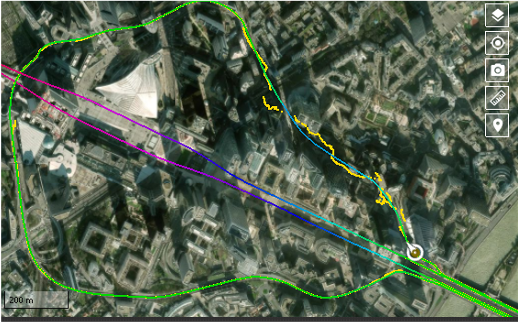
The Virtual Base Station to Maximize Corridor Survey Accuracy
The Virtual Base Station (VBS) consists in computing a virtual network around your project in which position accuracy is maximized, homogeneous, and robust. Surveyors can collect data far from base stations or over large areas, making it ideal for corridor mapping.
How does a Virtual Base Station Work?
Virtual Base Station
|

 Qinertia VBS implementation is particularly efficient in processing VBS networks, with a distance from the rover to the bases easily reaching up to 100km or more. This feature greatly extends the availability of PPK.
Watch the demonstration of a VBS generated by Qinertia, SBG’s in-house post-processing software.
Post-processing Accessible to All Surveying Applications

The UK-based company Unmanned Survey Solution (USS) has created this unique Unmanned Surface Vessel called the “Accession Class USV” equipped as standard a multibeam echo-sounder coupled with a mobile LiDAR for mapping terrestrial structures to create a full 3D point cloud above and below water. “In such situations, the centimetric level RTK position accuracy is greatly improved using SBG’s post-processing software called Qinertia. This PPP and PPK capable software offers single or virtual base station modes and can even incorporate users’ own base station RINEX data”, explains James Williams, CEO of USS.
Post-Processing Accessible to All Surveying Applications

Photos: SHOM, Courtesy Photo 512th Engineer Detachment, Viametris, ASTRALiTE
Post processing is now affordable and accessible to all surveying applications such as UAV-based surveying, Backpack or car-based mobile mapping, or hydrography.
Qinertia: One PPK Software for All your Projects

- Automatically selects the best positioning algorithm whether it is a single base station mode, the Virtual Base Stations mode, or a Precise Point Positioning computation
- The fastest post-processing as it parallelizes the calculation of every base station in the virtual network and simultaneously processes the Forward and Backward computations
- Open to third-party IMUs: several IMU and INS have already been successfully integrated with Qinertia including LN-200, LCI-100, and μIMU.
- Post-process data from any GNSS receiver through RINEX and with binary files from Novatel, Septentrio, Trimble, and Ublox for a straightforward workflow.

This page was produced by North Coast Media’s content marketing staff in collaboration with SBG Systems. NCM Content Marketing connects marketers to audiences and delivers industry trends, business tips and product information. The GPS World editorial staff did not create this content.