
No audio available for this content.
Russian military doctrine assumes GLONASS and other GNSS will not be available once a battle begins, so will instead turn to Loran-C for navigation
Russian forces are expert at jamming and spoofing GNSS. As a result, military analysts say, Russian military doctrine assumes that signals from space, including it’s own GLONASS and other GNSS, will not be available once a battle begins.
According to the Russia and CIS Radionavigation Plan, the terrestrial Chayka system, a version of Loran-C, is maintained to protect their homeland with navigation and timing services when signals from space are not available. The portable Skorpion system is designed for military use during expeditions to areas where Chayka or Loran is not available, according to western military analysts.
“Fixed Chayka transmission sites operate between 90 Khz and 110 Khz. Power output is typically between 200 and 800 kW with effective ranges over land of about 800 miles and over water of 1,000 miles,” explained Dana Goward, president of the Resilient Navigation and Timing Foundation. He noted that little information is publicly available about the military Skorpion system.
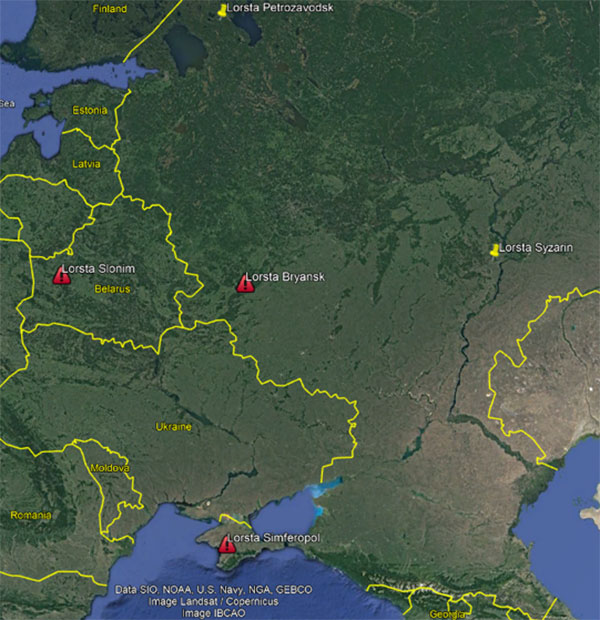
“Three of Russia’s Chayka/Loran stations have Ukraine surrounded,” explained UrsaNav CEO Charles Schue, referring to a graphic he provided GPS World. “They provide ideal coverage and will allow navigation accuracy of between 20 and 50 meters over most of the Ukraine. Upgrading to an eLoran equivalent could give them 5-to-10-meter accuracy, but I am sure the current setup is more than adequate for their purposes at the moment.”
Schue was the first commanding officer of the U.S. Coast Guard’s Loran Support Unit and the first program manager for the congressionally mandated Loran Modernization and Recapitalization project that was upgrading the U.S. Loran-C system to eLoran. As CEO of UrsaNav, he is helping several countries with Loran-C and eLoran projects.
One of the three surrounding Loran transmission sites is in the Crimea, which Russia invaded and annexed in 2014.
“The primary reason for taking Crimea may have been ensuring access to the ocean,” Schue said, “but it also allowed them to regain control of the Loran transmission site there. This has assured them sovereign terrestrial PNT [positioning, navigation and timing] for the entire region, including the Black Sea.”
A 2017 coverage map from Russia’s Internavigation Research and Technical Centre of Advanced Navigation shows Chayka serving eastern Europe, western Russia, and almost all of the Black Sea.


