No audio available for this content.
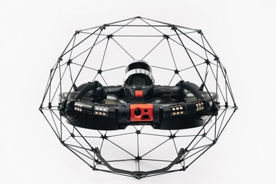
Flyability has unveiled the Elios 3, a collision-tolerant drone equipped with a lidar sensor for indoor 3D mapping. The drone is powered by a new SLAM engine called FlyAware that lets it create 3D models as it flies.
It also is accompanied by a new version of Flyability’s software for inspectors, Inspector 4.0.
The launch of the Elios 3 marks a new partnership with GeoSLAM. The Elios 3 comes with an Ouster OS0-32 lidar sensor, allowing inspectors to collect data for the creation of survey-grade 3D models using software from GeoSLAM.
The drone gives users real-time digital replicas of previously inaccessible areas with the inclusion of the lidar sensor and GeoSLAM’s Connect software. The drone is protected by a cage and has advanced collision-tolerance features that allow inspectors to fly it inside dangerous confined spaces such as boilers, pressure vessels and mines.
With its integration with Connect, the Elios 3 creates survey-grade point clouds. Fitted to the back of the drone, the lidar sensor maps the environment in real time using Flyability’s FlyAware SLAM algorithm.
Survey package option
Those that need highly accurate data can upgrade to the survey package, provided by GeoSLAM, providing access to the Connect software, as well as specialist Volumes and Draw modules. Powered by GeoSLAM’s established SLAM algorithm, Connect offers a simple and automated way to process point cloud data.
Using the survey package, data is processed to an accuracy of 8 mm, suitable for mapping hazardous environments such as mines and industrial applications including chimneys, production plants, warehouses, silos and tanks. Processed data can then be viewed in the easy-to-use 3D viewer and exported to industry-standard file types including LAZ, LAS, PLY and TXT for use in third-party software.


