No audio available for this content.
Focal Point Positioning, a software provider of reliable GNSS solutions, has released the results of a benchmark study conducted in central London, showing that integrating its S-GNSS Auto software with STMicroelectronics’ Teseo platform delivers measurable and consistent improvements in urban positioning performance. The results demonstrate that the combined solution provides the most accurate horizontal positioning among the receivers evaluated in deep urban conditions.
In a head-to-head benchmark using recorded GNSS signals from some of central London’s toughest urban environments, the combined FocalPoint–STMicroelectronics solution cut worst-case positioning errors by up to 32% compared with other commercially available receivers tested under identical conditions. These “urban canyon” scenarios, characterized by tall buildings, signal blockage, and multipath reflections, are among the most challenging for GNSS receivers to maintain accurate positioning.
To ensure a fair and repeatable comparison, the study captured raw GNSS radio frequency (RF) data during the drive and fed it into multiple receivers under identical conditions. A survey-grade GNSS/Inertial Measurement Unit (IMU) system provided centimeter-level ground truth positioning, allowing precise evaluation of horizontal positioning error across all devices tested.
Across both statistical and spatial analyses, the data showed a clear performance advantage for the S-GNSS® Auto solution on the Teseo platform. The combined solution consistently delivered the most accurate horizontal positioning among the evaluated receivers across the full urban route.
At the 95th percentile, representing performance in the most challenging conditions, the TeseoVI and S-GNSS solution achieved a horizontal positioning error of 7.0 m. This was compared with 10.3m to 11.0 m for other standalone receivers and 21.2 m for a modem-based solution. This equates to a reduction of up to 32% in the largest positioning errors.
“This data shows that in the most challenging urban conditions, where GNSS performance typically breaks down, our combined solution can help significantly reduce the largest positioning errors,” explains Jez Ellis-Gray, lead product manager at Focal Point Positioning. “This translates directly into more consistent and reliable positioning for real-world applications, without the need for complex additional hardware.”
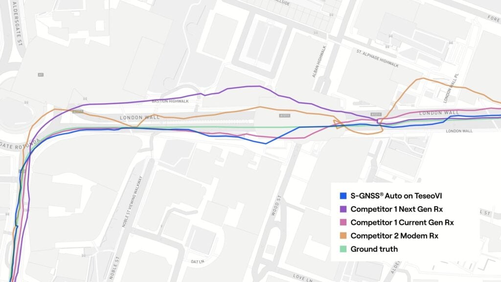
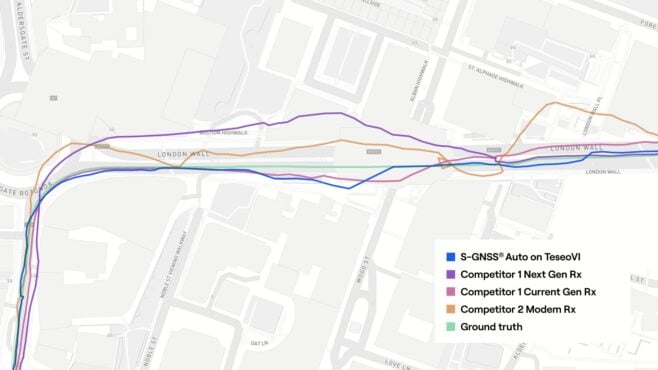
The map-based trajectory comparison further supports these statistical results. In dense urban segments, including the corner around the ‘Walkie-Talkie’ building on Fenchurch Street, the Camomile Street to Wormwood Street transition and along the London Wall, the TeseoVI and S-GNSS trace shows tighter alignment to ground truth. Deviations observed in alternative solutions, particularly during turns and in street canyons, were visibly reduced in the S-GNSS-enabled solution.