 Whether you’re surveying an oil pipeline to prevent spills, guiding a rover through a tunnel or managing crane productivity for dredging operations, there’s one requirement that is a necessity for the success of an operation requiring precise positioning: accuracy. Integrating high-precision GNSS solutions into an application helps reduce development times, boosts production and efficiency, and allows an application to operate in harsh environments, just to name a few.
As a recognized manufacturer of high-precision positioning solutions, the Trimble InTech team aims to provide technology that maximizes productivity and enhances profitability for their customers. The products and solutions available utilize a start-to-finish approach that enables integrators to take advantage of a complete technology package that provides robust precision accuracy and fully streamlined integration for an application.
Trimble customers CEE HydroSystems and PT Timur Bahari have integrated Trimble’s high-precision GNSS technology into their applications to tackle some of their toughest challenges:
- CEE HydroSystems: Surveying on the Trans-Alaska Pipeline
- PT Timur Bahari: Custom waterproof RTK GNSS system
Read more case studies on the Precision GNSS homepage.
Trimble and CEE™ HydroSystems — Surveying on the Trans-Alaska Pipeline
Application: Unmanned Survey Vessel
Trimble Products Used: Trimble BD970 GNSS Receiver, Trimble GA830 Antenna
The Aleyska Pipeline Service Company’s mission is to provide safe, environmentally responsible, reliable and cost-effective oil pipeline transportation along the North Slope of Alaska. CEE™ HydroSystems teamed up with Trimble to develop a solution to better monitor the Trans-Alaska Pipeline System (TAPS) at 34 major river crossings and 500 small stream crossings along the route.
Having any exposed sections of the pipeline can present a major failure risk, and any error can be detrimental to the surrounding environment. Alyeska surveyors needed a solution that allowed them to survey the pipeline at the river and stream crossings in a timely manner while receiving accurate real-time data.
To accomplish this, the surveyors implemented a USV survey program using the Trimble GNSS-equipped RTK CEESCOPE™ on board the CEE-USV™ — and improved surveying efficiency and tactics along an 800-mile stretch of Alaska pipeline.
Trimble and PT Timur Bahari — Custom waterproof RTK GNSS system
Application: Dredger
Trimble Products Used: Trimble BX992 GNSS Enclosure, Trimble AV28 Antenna
PT Timur Bahari, a well-known company in Indonesia, develops customized dredging operations for their customers. The company was hired to place seawater intake pipes and risers for a coal-fired steam power plant, but it faced many setbacks during the start of the project — including the extended amount of time it took to achieve correct crane positioning for pipe placement.
Trimble was brought in to provide a rugged solution with high-precision positioning abilities. With the Trimble BX992 high-precision enclosure and AV28 multi-frequency antenna aboard the system, crane operators could accurately lay the pipes as required underwater by simply controlling them from the crane on the barge.
By integrating Trimble high-precision GNSS technology into PT Timur Bahari’s custom dredging system, the company saw a boost in productivity, ease of control and accurate underwater pipe placement.
Trimble InTech (Precision OEM GNSS): What You Need to Know
With years of engineering, testing and customer experience, Trimble InTech is changing the way it educates its readers. With the endless number of factors that go into developing the correct solution for your positioning and orientation needs, there are things you should know to find the best fit.
When considering a high-precision GNSS solution for your application, it’s important to think outside the box and envision your end goals for your application before making a purchasing decision. Consider the following questions:
- What scenario is the application being used in?
- What are the end goals of the application in this scenario?
- What kind of environment will it be operating in?
- Are there obstructions in the environment that can disrupt the application?
- Are there safety precautions needed? Will the integration of the technology be seamless with your application?
Stay educated with the start of Trimble’s “What You Need to Know” series. Check out short overviews on important topics such as:
- Does your application require a single- or dual-frequency receiver?
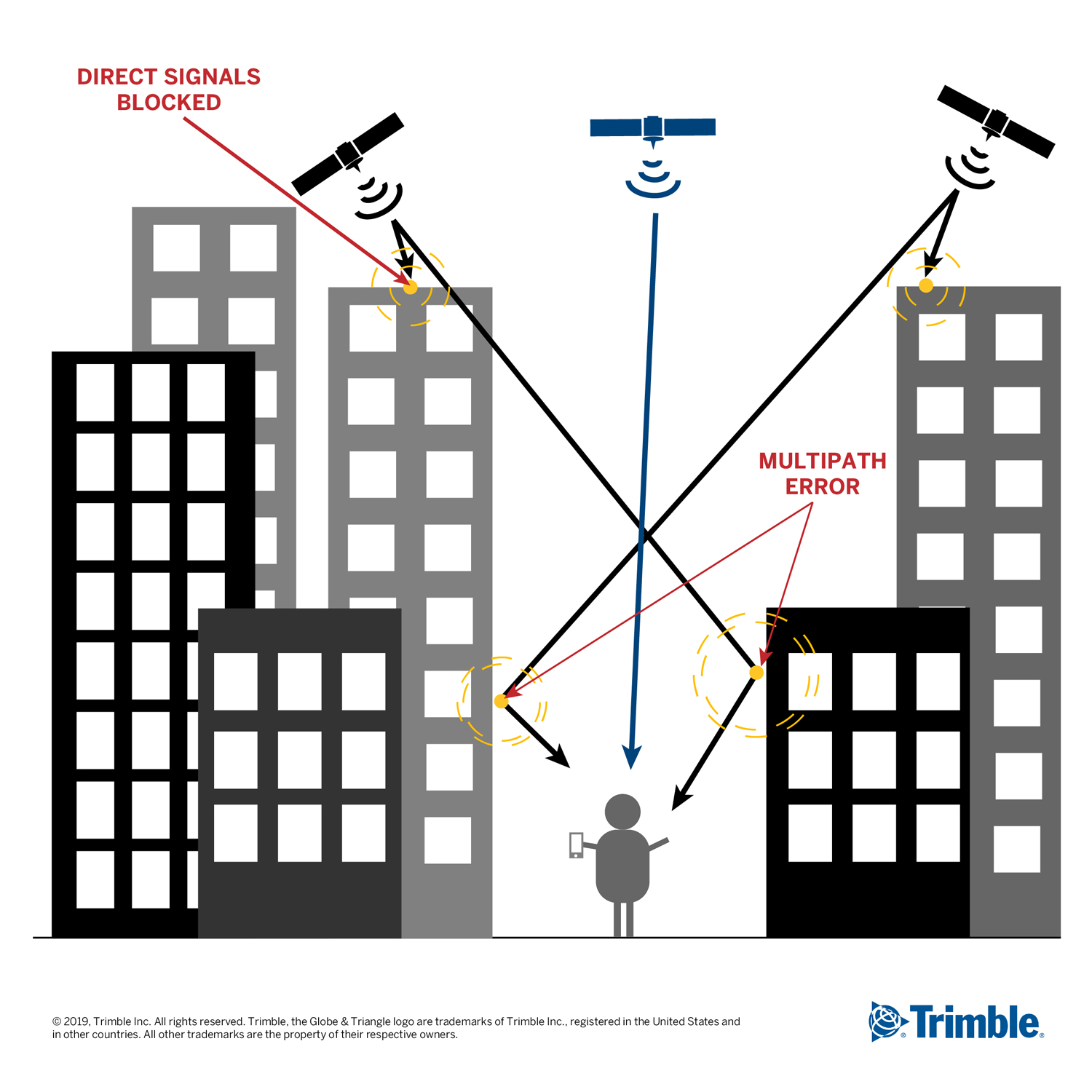
- What is multipath and what are some solutions to combat those signals?
Contact the Trimble team to see how they can support your application no matter the type of challenging environments. Trimble is a supplier of GNSS products to a wide variety of OEMs and systems integrators across numerous verticals, including autonomous navigation, agriculture, survey and mapping, marine, construction, mining and aviation. By also integrating inertial sensors directly into some of the GNSS modules, users can experience a more robust performance in a variety of challenging environments, such as urban canyons, tunnels, heavy canopy or other GNSS denied environments.
This page was produced by North Coast Media’s content marketing staff in collaboration with Trimble InTech. NCM Content Marketing connects marketers to audiences and delivers industry trends, business tips and product information. The GPS World editorial staff did not create this content.
Header images: Trimble InTech