Listen to this content
Incorporating a layered horizontal gradient structure can improve GNSS-Acoustic (GNSS-A) seafloor positioning, according to a new research paper in the April 20 issue of Satellite Navigation.
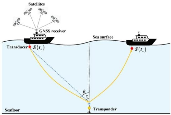
GNSS-A integrates satellite positioning of a sea-surface platform with underwater acoustic ranging to achieve seafloor positioning accuracy at centimeter level. This technique supports the construction of seafloor geodetic observation networks, improves the oceanic component of the International Terrestrial Reference Frame (ITRF), and provides a key means for monitoring tectonic deformation and related submarine geohazards.
However, the accuracy of GNSS-A seafloor positioning is affected by spatiotemporal variability in the ocean sound speed field. The conventional depth-invariant horizontal sound speed gradient models represent the water-column sound speed structure using a single effective depth-averaged gradient, which cannot adequately describe the vertical heterogeneity of horizontal gradients and therefore introduce model errors and positioning biases.
To address this issue, the authors propose a layered sound-speed gradient model and a corresponding joint inversion framework for precise GNSS-A seafloor positioning.
The proposed method parameterizes horizontal sound-speed gradients in multiple depth layers and couples adjacent layers through depth-weighted interlayer continuity constraints, which jointly estimates seafloor transponder coordinates, the depth-invariant temporal perturbation, and layer-wise horizontal gradients.
Results of simulations
Simulation results under depth-dependent horizontal gradient scenarios show that the conventional single-layer model introduces systematic positioning biases, whereas the proposed layered model significantly improves positioning accuracy, accurately estimates the temporal perturbation and layer-wise horizontal gradients, and is robust for a broad range of layering configurations and constraint parameters.
Field experiments using real GNSS-A observations further demonstrate the practical value of the proposed method, with results showing that the proposed approach improves the fitting of acoustic observations, maintains short-term repeatability, and yields consistent multi-epoch coordinate time series together with reasonable site-velocity estimates.
These findings indicate that incorporating a layered horizontal gradient structure can improve GNSS-A seafloor positioning and provides an interpretable modeling and inversion framework for long-term seafloor deformation monitoring and characterization of ocean environmental variability.
“Precise acoustic seafloor positioning with joint estimation of sound speed field structure using a layered sound speed gradient model,” by Yang, W., Xu, T., Wang, J. et al, can be downloaded from Springer’s website.