USGS upgrading Hawaiian geodetic network to monitor volcanoes
August 26, 2022
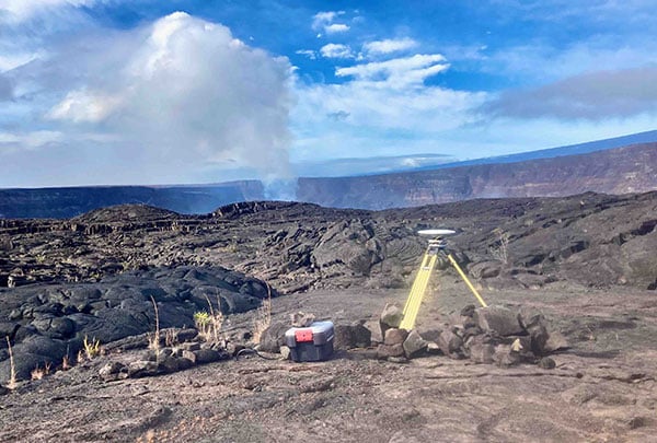
The Hawaiian Volcano Observatory (HVO) of the U.S. Geological Survey has been working to rebuild its geodesic monitoring […]
Read More
The Hawaiian Volcano Observatory (HVO) of the U.S. Geological Survey has been working to rebuild its geodesic monitoring […]

“Seen & Heard” is a monthly feature of GPS World magazine, traveling the world to capture interesting and unusual news […]
Geospatial companies played a key role in the government’s response to the Kilauea Volcano eruption. The volcano on the Big Island of Hawaii began erupting May 3, and while quiet for more than a week, it could resume erupting at any time.

High-resolution lidar surveys help first responders, scientists and government agencies monitor Kilauea conditions and predict future lava flows. […]

GPS measurements are playing a key role in monitoring the erupting Kilauea volcano in Hawaii. The floor of […]

New U.S. Geological Survey (USGS) maps show areas that could be affected by Mauna Loa lava flows — […]


Follow Us