AG Surveys collects topographic beach surveys throughout England
April 1, 2020
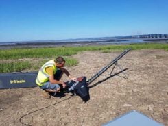
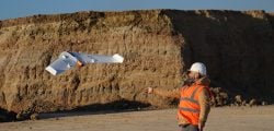
Based in Bristol, AG Surveys has been collecting topographic beach surveys around the country as part of England’s […]
Read More
Based in Bristol, AG Surveys has been collecting topographic beach surveys around the country as part of England’s […]

When Trimble sold its Gatewing fixed-wing drone business to Delair in October 2016, its decision was based on […]

This report covers a number of UAV topics, including the news of another U.S. Federal Aviation Administration (FAA) […]
GNSS receiver manufacturer Septentrio has been selected to supply its high-precision AsteRx-m2 GNSS OEM receiver module and PPK […]

Delair, a supplier of drone solutions for commercial industries, has introduced the next-generation of its high-performance DT26X Lidar UAV. […]

Commercial drone-maker Delair has introduced a professional unmanned aerial vehicle (UAV) for survey-grade photogrammetric mapping. The UX11 is a […]

NASA’s UTM. On May 25, the Federal Aviation Administration (FAA)-designated Nevada UAS Test Site and its NASA partners […]
Strategic alliances with Delair-Tech and Microdrones expand UAS platform options while leveraging Trimble software and data solutions. Delair-Tech […]


Follow Us