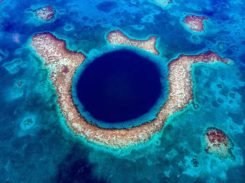
Belize’s Great Blue Hole revealed in expedition survey
September 10, 2019
A sonar survey, camera and sensor data of the world’s largest marine sinkhole is shining light on sea […]
Read More
A sonar survey, camera and sensor data of the world’s largest marine sinkhole is shining light on sea […]

TCarta Marine, a global provider of geospatial products and services, has been contracted by the United Kingdom Hydrographic […]

News from the European Space Agency (ESA) Two tiny GNSS-RO nanosatellites now circle the Earth, ready for action. The […]
The entirety of West Antarctica contains enough ice that, if it were to melt, would cause oceans to […]
Esri has launched the Africa GeoPortal, a comprehensive cloud-based platform that provides rich content and solutions from Esri […]
Leigh Stearns, a geologist with the University of Kansas, is working with a Riegl VZ-6000 ultra long range […]

In life, few things are certain. In family, love and friendship, fewer. Add more people — workplace, groups, […]
The Washington Post reported March 3 that the Trump administration proposes slashing the budget of the National Oceanic and Atmospheric […]


Follow Us