Skyward releases airspace maps, access for drone pilots

The drone operations management platform provides information on 3D vertical structures and obstacles, and access to digital airspace, to improve drone flight safety.
Skyward, a Verizon company, has introduced Advanced Airspace Intelligence for drone pilots.
Skyward’s drone airspace maps provide airspace data combined with essential ground intelligence including 3D views of key structures, transmission lines, and more than a million vertical obstacles.
The platform also provides access to LAANC, the Low Altitude Authorization and Notification Capability program provided by the U.S. Federal Aviation Administration.
Drone pilots in the field need to know how the surrounding area, including infrastructure, could affect flight, and Skyward offers this critical safety data to all users.
Skyward introduces Advanced Airspace Intelligence from SkywardIO on Vimeo.
“Showing airspace is important, but it’s only part of the picture. The more intelligence that is available to understand how an area will affect the flight, the less risk a pilot has in the field,” said Mariah Scott, president of Skyward. “Skyward Airspace Intelligence is the only solution that provides easy-to-understand data for things like transmission lines, runways, over a million vertical obstacles, and a 3D view of key structures. It’s the next best thing to physically being in the field.”
In addition to comprehensive airspace information, the following data is now available for situational awareness:
- Vertical structure obstacles (over one million structures identified from the FAA and FCC databases)
- Major power transmission lines
- Airports
- Runways
- Heliports
- U.S. and Canadian National Parks
- Stadiums
- Hospitals
- Schools
- Pedestrian walking paths
Skyward Airspace Intelligence is part of a complete workflow that enables pilots mitigate weather, environment and business-specific risks.
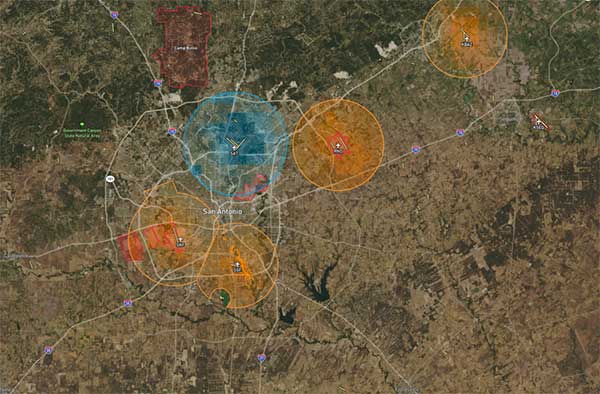
Image: Skyward


About the Author: Tracy Cozzens
Senior Editor Tracy Cozzens joined GPS World magazine in 2006. She also is editor of GPS World’s newsletters and the sister website Geospatial Solutions. She has worked in government, for non-profits, and in corporate communications, editing a variety of publications for audiences ranging from federal government contractors to teachers.


Subscribe to GPS World
If you enjoyed this article, subscribe to GPS World to receive more articles just like it.


Follow Us