GMV joins Lockheed in SouthPAN development

Multinational technology firm GMV has signed an agreement with Lockheed Martin Corporation to develop the processing and control centers for the Southern Positioning Augmentation Network system (SouthPAN). Lockheed is contracted to establish SouthPAN.
The project is a joint initiative of the Australian and New Zealand governments to provide a satellite-based augmentation system (SBAS) for navigation and precise point positioning (PPP) services. GMV will also be responsible for monitoring both of these services in the region and for ensuring compliance with the committed performance levels.
SBAS and PPP systems have applications in industries as diverse as agriculture and road, air, maritime and rail transportation, as well as in the field of geomatics. SouthPAN is expected to accelerate development of applications in these areas.
SouthPAN is also the first system with these characteristics available in the Southern Hemisphere. With this new program, Australia and New Zealand will be contributing to improved global coverage and interoperability for services of this type, joining the list of countries and regions that already have their own SBAS system: the United States (WAAS), Europe (EGNOS), India (GAGAN) and Japan (MSAS).
On Sept. 26, two weeks after the agreement was signed, the first services were provided by activating transmission of the system’s first signals. This was a significant milestone, because SouthPAN is the first project where an industry consortium provides an SBAS as a service, rather than as a turnkey system.
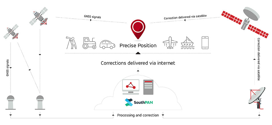
Image: SouthPAN
GMV’s role
GMV will be responsible for developing two key subsystems for SouthPAN: the Corrections Processing Facility and the Ground Control Center. The company will also be responsible for monitoring the system and ensuring it complies with the committed performance levels.
GMV also will provide support for the system’s operation and maintenance.
Corrections Processing Facility. The facility generates correction messages for signals transmitted by GPS and Galileo, improving precision for users by improving accuracy to as little as 10 centimeters.
The facility also detects malfunctions in the satellites and generates warnings for users. This will allow use of SouthPAN by civilian aircraft as a navigation system during various flight operations, including precision approaches to runways for landing.
Safety-of-life services such as these will be available in 2028.
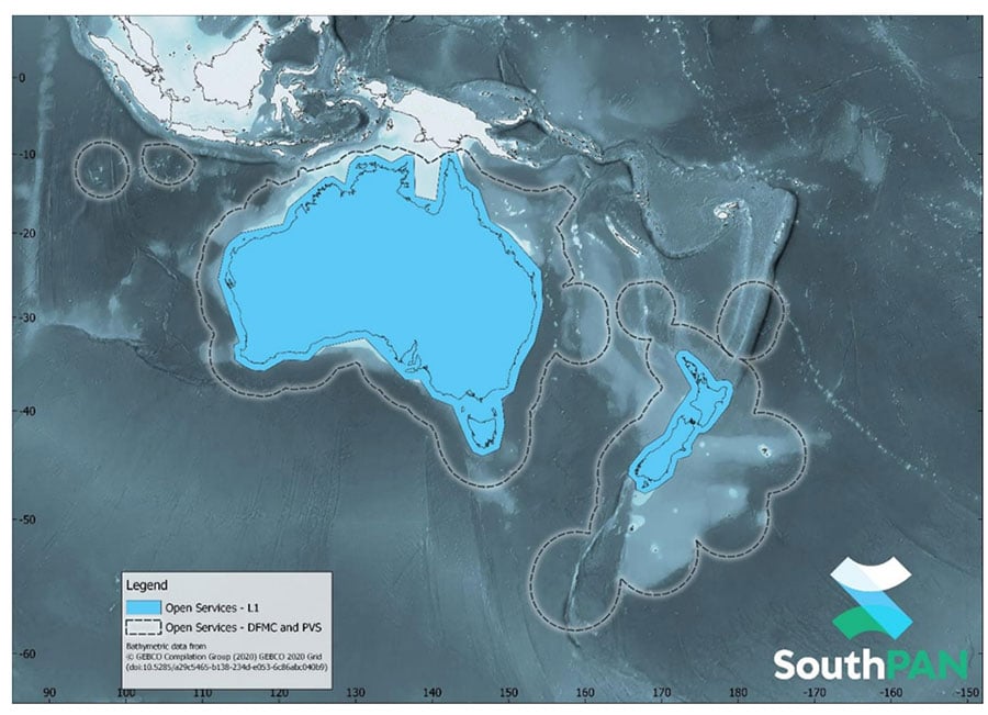
SouthPAN early Open Services coverage. OS-L1 covers mainland Australia and New Zealand. OS-DFMC and OS-PVS cover Exclusive Economic Zones in both countries. (Image: Geosciences Australia)
Ground Control Center. The control center remains in operation 24 hours a day seven days a week, and will perform all the functions needed to monitor and control the system. It will also provide information to users about the system’s operation and availability of services.
In Australia, SouthPAN development, entry into service and operation are being supervised by Geoscience Australia in collaboration with Toitū Te Whenua Land Information New Zealand.
In 2020, the two agencies signed the Australia New Zealand Science, Research and Innovation Cooperation Agreement (ANZSRICA). Over the next 20 years, the Australian government will be contributing 1.4 billion Australian dollars to the SouthPAN project.


About the Author: Tracy Cozzens
Senior Editor Tracy Cozzens joined GPS World magazine in 2006. She also is editor of GPS World’s newsletters and the sister website Geospatial Solutions. She has worked in government, for non-profits, and in corporate communications, editing a variety of publications for audiences ranging from federal government contractors to teachers.


Subscribe to GPS World
If you enjoyed this article, subscribe to GPS World to receive more articles just like it.


Follow Us