No audio available for this content.
Chronos Technology is introducing the academic and business research consortium working on the GAARDIAN Project at its booth (#728) at the ION GNSS conference taking place this week in Savannah, Georgia. Chronos is leading the consortium, which over the course of 2009 – 2011 will be researching the data-gathering necessary to develop a system for mission and safety critical applications that will certify the accuracy, reliability, integrity, and continuity of Positioning, Navigation and Timing (PNT) systems: GPS, the new enhanced LORAN (eLORAN), GALILEO and GLONASS.
GAARDIAN is the acronym for “GNSS Availability, Accuracy, Reliability anD Integrity Assessment for Timing and Navigation” and the Consortium includes University of Bath, General Lighthouse Authorities, BT, Ordnance Survey, National Physical Laboratory, and Imperial College London.
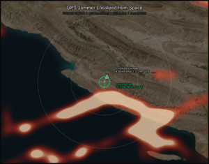
The project will create a mesh of remote PNT (Positioning, Navigation & Timing) interference detection & mitigation sensors (IDMs) which will be deployed in the vicinity of PNT dependent infrastructure & applications. These probes will monitor the integrity, reliability, continuity and accuracy of the locally received GPS (or other GNSS) and eLoran signals on a 24×7 basis and report back to a central server. The user will be alerted in real time to any anomalous behavior in either of the two PNT signals.
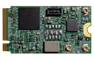
IDM sensors, which can be configured by the user to be personalized to a specific deployed location, permanently monitor the PNT signals and on detection of an anomaly warn of a potentially critical situation.
Users access the data over the internet from a secure server environment, enabling continuous monitoring from any internet enabled terminal – effectively providing access to detailed knowledge about local PNT health and pinpointing interference phenomena from anywhere in the world.
Likely phenomena or threats to PNT services which would cause an alarm include jamming, general interference, multipath from local reflections, space environment or weather related events and satellite or transmitter malfunction.
Traditionally it has been very difficult to analyze the specific nature of interference to a PNT signal, when monitoring one signal alone, e.g. GPS. By using the technically dissimilar eLoran signal and continually analyzing key data, the integrity, reliability, continuity and accuracy of either signal can be recorded with high confidence.
Likely applications will include homeland security, transport users such as harbors, airports, roads and railways, emergency services, military, utilities, scientific community, telecom infrastructure and any safety or mission critical application leveraging PNT signals.